Home
About the Project
About the project
We are reviewing active travel options to improve the walking and cycling environment for residents and visitors in Benllech. This study builds on previous studies and there are now five short-listed active travel corridors and a placemaking enhancement around the Square in Benllech village centre. The overall aim of the project is to maximise opportunities for people to travel by sustainable modes within and to Benllech
Click through the contents list below for further information on the proposed improvements at each corridor and to view plans for each.
Contents List:
- Summary (About the Project)
The Square – Junction improvement with raised table pedestrian crossings, resurfacing, and tightened radii.
Beach Road (Corridor 1) - One-way system on Beach Road (eastbound) and separate two-way cycle lane/shared use path.
A5025 Amlwch Road from The Square to Bodafon Caravan Park (Corridor 2) – 20mph speed limit, resurfacing, and footway widening.
A5025 towards Red Wharf Bay (Corridor 3) – 20mph limit, shared use path, side road improvements, and improved pedestrian space.
B5108 towards Brynteg (Corridor 4) – One-way system westbound, shared use space conversion, junction changes, and signage.
Lon Pant Y Cudyn (Corridor 5) – New uncontrolled crossings, 20mph limit, and grass verge conversion to footpath or shared use path.
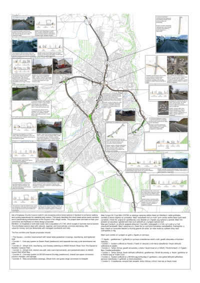
Overview of the corridors within Benllech.

Summary (About the Project)
For further information on each corridor please scroll to the bottom of the page and click Next.
Transport Appraisal Guidance (WelTAG) Stage One and Two Study was undertaken between January 2022 and May 2022.
The Stage One & Two focused on identification of the key corridors for movement in Benllech.The project forms Stage Three of the Study, aiming to identify the preferred improvements along each corridor with your support.
The study identified an extensive list of problems which include:
- Limited active travel infrastructure provision.
- Lack of safe and suitable crossing places.
- Residents do not feel safe to walk and cycle.
- The highway network dominated Benllech with poor environment active travel issues.
- High traffic volumes and speeds deter active travel.
- A need to improve safety and the square.
The objectives of the study include:
- Promoting and prioritising active travel journeys.
- Improving opportunities for healthier lifestyles.
- Increasing the number of trips made by walking and cycling for commuting and leisure.
- Creation of attractive, accessible and comfortable walking and cycling routes.
- A safe and cohesive network by improving safety at the Square.
- Making Benllech a more attractive place to live, work, and visit.
Proposed Improvements
The proposed improvements have been identified based on a review of the existing challenges in Benllech, concerns raised by residents during consultations, and alignment with policies and objectives.

Overview map summarising the proposed improvements across all corridors.
Click below to view PDF
Click Next below to view The Square
Or to view the other pages click below:
The Square
Please scroll to the bottom of the page to view all plans and visualisations, and click next to view the next corridor.
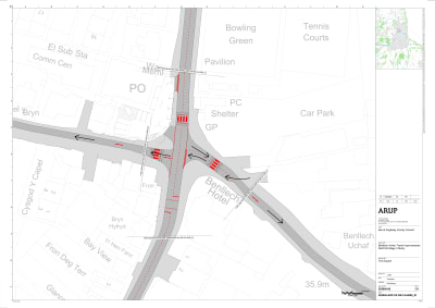
The emerging option to improve safety for people at this junction is to:
- Provide more footpath space on the corners of the junction.
- Move the pedestrian crossing to be closer to where people want to cross, and add crossings on the other arms.
- The introduction of one-way systems on Corridors 1 and 4 would reduce the number of car turning at the junction, improving safety for pedestrians.
 Drawing illustrating the proposed improvements at The Square (including more footpath space and locations of the proposed pedestrian crossings).
Click below to view PDF


Click Next at the bottom of the page to view Corridor 1.
Or to view the other pages click below:
Corridor 1: The Square to Bay View Road (Via Beach Road)
Please scroll to the bottom of the page to view all plans and visualisations, and click next to view the next corridor.
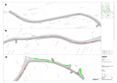
The emerging preferred option for this road is Option 1a to:
- Construct a shared use path.
- Introduce a one-way system southbound between the Square and Upper Wendon Car Park including traffic calming features.
- Add a pedestrian crossing near the Beachfront.
- Retain most of the parking bays along the Beachfront.
Corridor 1: Other options
These are not the emerging preferred options due to space constraints:
- Option 1b: Widened footways on both sides of the road.
- Option 1c: Segregated cycle track.
- Option 1d: Contra-flow cycle lane.
 Drawing illustrating the layout of the proposed improvements of Option 1a along Corridor 1 (The Square to Bay View Road via Beach Road)
Click below to view PDF


 Cross Section showing the proposed improvements along Corridor 1 at the Court House.

Cross Section showing the proposed improvements along Corridor 1 at the Sea Front.
Click Next below to view Corridor 2
Or to view the other pages click below:
Corridor 2: A5025 Amlwch Road (The Square to Bodafon Caravan Park)
Please scroll to the bottom of the page to view all plans and visualisations, and click next to view the next corridor.
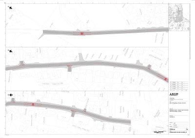
The emerging preferred option for this road is to:
- Bus lay-by to be infilled so more footway space is provided for pedestrians.
- Pedestrians crossing to be added near playground.
- Localised widening of the footways.
 Drawing illustrating the proposed layout and improvements for corridor 2 A5025 Amlwch Road (The Square to Bodafon Caravan Park)
Click below to view PDF
 Cross Section showing the proposed improvements along corridor 2 A5025 Amlwch Road (The Square to Bodafon Caravan Park) at the disused bus stop.

Cross Section showing the proposed improvements along corridor 2 A5025 Amlwch Road (The Square to Bodafon Caravan Park) at the bus stop.
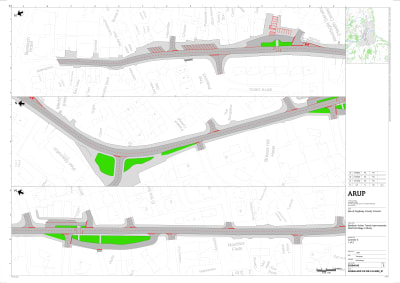
Corridor 3: A5025 Bangor Road (The Square to Bwlch Road)
Please scroll to the bottom of the page to view all plans and visualisations, and click next to view the next corridor.
The emerging preferred option for this road is to:
- Re-design of parking outside Benllech Dental Surgery to provide more footway space.
- Widening and resurfacing of the footways.
- Shared use path on the eastern footway between Bwlch Road and Garreglwyd.
- Formalise lay by area in fron of butchers with a dropped kerb.
- New crossing near Bwlch Road and Rhianfa / Bangor Road junction to provide sage access between bus stops.
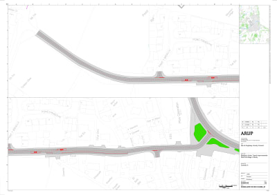
 Drawing illustrating the proposed improvements along the northern section of Corridor 3: A5025 Bangor Road (The Square to Bwlch Road)
Click below to view PDF

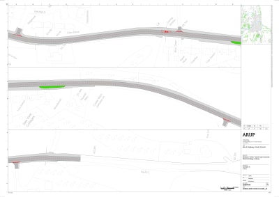
Drawing illustrating the proposed improvements along the southern section of Corridor 3: A5025 Bangor Road (The Square to Bwlch Road).
Click below to view PDF
 Cross Section showing the proposed improvements along Corridor 3: A5025 Bangor Road (The Square to Bwlch Road) at the Breeze Hill Hotel.

Cross Section showing the proposed improvements along Corridor 3: A5025 Bangor Road (The Square to Bwlch Road) at the Petrol Station.
 Cross Section showing the proposed improvements along Corridor 3: A5025 Bangor Road (The Square to Bwlch Road) at the Bus Stop.

Cross Section showing the proposed improvements along Corridor 3: A5025 Bangor Road (The Square to Bwlch Road) along the Public Right of Way.
Click Next at the bottom of the page to view Corridor 4.
Or to view the other pages click below:
Corridor 4: B5108 Llangefni Road
The emerging preferred option for this road is Option 4f to:
- Introduce a one-way to Craig-Y-Don from The Square with parking including traffic calming features.
- Widen the footway on one side of the road to create more space for pedestrians and a shared cycle track.
Corridor 4: Other options
- Option 4a: Introduce a one-way section eastbound from The Square until Lon Pant Y Cudyn (just left of the Fire Station).
- Option 4b: Shared use path.
- Option 4c: One-way all the way to the junction and segregated cycle track eastbound.
- Option 4d: Shared use path with turning area.
- Option 4e: One-way to Craig-Y-Don from the Square.


 Drawing illustrating Option 4f outlining the proposed one-way system to Craig Y Don from the Square.
 Drawing illustrating the preferred option 4f and proposed improvements to include a one-way system to Craig-Y-Don from The Square with parking.
Click below to view PDF
 Cross Section showing the proposed improvements for Option 4E along Corridor 4: B5108 Llangefni Road.

Cross Section showing the proposed improvement for the preferred Option 4f including parking.
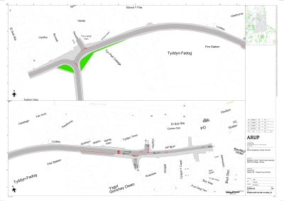
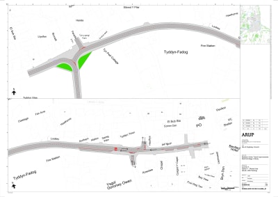
Corridor 5: Lon Pant Y Cudyn
The emerging option to improve safety for people at this junction is to:
- New footpath on the left-hand side of the road which would replace the existing grass section.
- Parking bays added to remove need for parking on footway.
- New bus stops.
- Traffic calming measures to encourage 20mph.

Drawing illustrating the proposed improvements along Corridor 5: Lon pant Y Cudyn.
Click below to view PDF
 Cross Section showing the proposed improvements along Corridor 5: Lon Pant Y Cudyn at the Bus Stop.
This engagement phase has finished

...